
WILLIAM PATTEN, MAPPING
William Patten school used to be one of the most polluted schools in London, and is situated near the junction of two busy main roads. Many families used to walk along the main roads (which are illegally polluted) to get to the school, as well as to the park, library and leisure centre.
After discovering that research showed that pollution levels can as much as halve just one road back from a main road, some parents at William Patten school thought it might be worth investigating whether this was the case in Stoke Newington.
ACTION
Two families who lived close to each other decided to compare different routes to school to see what difference it could make. Wearing pollution monitors, one family walked their normal route along the main roads (shown in blue arrows on the map below), and the other family chose the back roads (purple arrows).
The monitoring conducted by the children showed that, on the backstreets, pollution can be up 50% lower than on the main roads. So they discovered for themselves that choosing back roads to get to school is a very simple way to reduce the amount of polluted air they breathe.


CREATING THE MAP
The year 4 classes at the school had a cross-curricular session on pollution and mapping, where they learnt what creates pollution in their area. They then guessed for themselves (correctly) which were most likely to be the most polluted streets in the area.
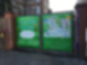
Then they drew pictures of their favourite places in the area. The pictures that were most suitable to be included were scanned and added to an illustrated map of the local area created by a parent who is an illustrator, and which had roads colour-coded to show which are polluted roads, and which have cleaner air.
The map highlights the most polluted streets (shown in grey) and recommends using alternative cleaner air routes (blue with white footsteps). The London Air pollution map of London was used to decide if a road was polluted (and therefore grey) or not.
DISSEMINATION
An A4 folded version of the map was printed and went home in every child’s book bag, with a letter explaining the project and encouraging families to stick the map on their fridge at home and choose the low pollution routes whenever they can.
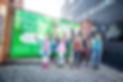
By putting a giant PVC banner version of the map up on some mesh gates that were between the playground and the bus stop, it helped to act as a barrier and keep out some of the traffic pollution from the playground, whilst also raising awareness about low pollution routes in the area.